By Anca Gagiuc on December 6, 2012 in Technology

Just in time for the holiday rush, Google brings shoppers, travelers and those who find themselves looking for an exit new access to indoor maps. The new service offers over 10,000 indoor layouts for malls, stores, museums, casinos, and airports from different parts of the world. The technology powerhouse is late to the indoor map market but brings volume and global reach – Microsoft’s Bing Maps has launched indoor maps in 2010 with 3,100 maps.
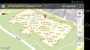
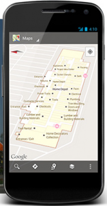
Currently the Google indoor map service is available in Belgium, Canada, Denmark, France, Japan, the United Kingdom, the United States, Sweden, and Switzerland. Navigating on Google Indoor Maps follows the same paths as exploring Google Maps. The steps to follow are simple:
- Find an available Indoor Maps location.
- Zoom into the map until you start to see an indoor floor plan of the building.
- Use the level switcher to move from the ground floor to other available floors in the building.
Searching works exactly as it does in the rest of Google maps for mobile, but the search results for Indoor Maps will only show when you’re fully zoomed into a building where an indoor map is available. The Android Latitude feature is seamlessly integrated with the indoor maps as well, thus allowing you to find your friends and children with a few simple touches of your mobile phone.
The service will expand with user uploads of building plans online. If you want to see your residential, commercial or retail property on the service, uploading is available in the US, UK, and Japan. Google is also starting to collect indoor images similar to Street View. The images will augment the floor plans and give you a look inside buildings around the world from your tablet, laptop or mobile device.
Here’s a tutorial on how to upload floor plans to Google Maps.
The most eager adopters, though, remain large retailers. One study claims that up to 20% of potential retail sales are lost because customers have trouble finding the items they want. Some department stores have created personalized apps that show the shopper their position in the store – represented by a blue dot – and give turn-by-turn directions to departments and brands in the building.Google aims for the jackpot with this new service. Some institutions have already converted their blueprints into detailed floor plans with critical infrastructure information and points of interest that can be easily accessed by firefighters and first-responders. Hospitals use it to help patients and visitors traverse mazes of connected and confusing buildings.

Google is striving for indoor maps that are “as solid and reliable as outdoors”, and this is one challenging mission. Gathering indoor maps means to acquire building maps from building owners, a system called by project leader Waleed Kadous a “chicken-and-the-egg” problem – users won’t use the service until more locations are supported, and businesses won’t provide maps until the consumer demand grows. Also, there is the GPS coverage problem that has to be addressed. GPS doesn’t work (properly) when the satellite signals are blocked, for indoor positioning new technologies are needed. The most affordable solution these days through which location can be triangulated without GPS is to use multiple Wi-Fi hotspots, but this way Maps could currently estimate a user’s location inside within 10 meters.
One potential solution may come from the Internet Engineering Task Force, a body that develops online standards, that proposes a set of location-related measurements and data-right disclosures. In August this year a trade organization formed In-Location Alliance – 22 technology companies including Nokia, Samsung, and CSR have joined forces to build indoor-location systems around Bluetooth beacons and Wi-Fi signal mapping.
Also making strides in the indoor positioning race is Nokia, which supplies indoor maps to Microsoft, and has visited more than 5,100 venues in 40 countries. Apple is also invested, maybe even more so since their overly-analyzed Maps service resulted in consumer outcry earlier this year, and dozens of smaller companies are also in the indoor hunt.
Once the specialists have established a sense of direction to the indoor positioning industry, any guesses on how this new service will impact the commercial real estate world? Will you upload maps of your properties to this service, or do you have privacy concerns?


