Some memories are so powerful that you’d want to mark them somehow more than just in your mind. Memories that you want to be able to access from miles away, simply displayed on a map, memories that describe themselves through photos, notes, and even videos. It can be a new place that you’ve visited, it can be a recurring place you go to for family reunions, it can be a restaurant that marks anniversaries with your loved one, your amazing work place, or even your home. Under this concept Findery landed on Google Maps. Serial entrepreneur Caterina Fake, known as the co-founder of Flickr, sensed the need for a tool that allows internet lovers to gather their memories in a soulful and sincere manner, without that “social peacocking” some of the apps today offer. She describes it as an attempt to bring humanity back on the internet, and the intention behind this new network is to tell the story of your life, connecting it with places. You are the one to decide of it’s for the general public or for your eyes only. Aside from the personal side of Findery, business owners can sign up for accounts. Real estate company Corcoran has already done so and is providing information about its properties and other local knowledge on the network, in an attempt to attract future clients. This tells a lot about the potential of this idea: out-of-towners, tourists or people who need to relocate due to their work or school, can easily learn about the new city from the people who placed notes with their experiences. Prospective renters could easily pull up Google Maps and search for apartment communities in the area they are interested in moving to. Everything is laid out on a...
Google Maps Goes Indoors...
Worldwide building plan data
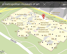
Just in time for the holiday rush, Google brings shoppers, travelers and those who find themselves looking for an exit new access to indoor maps. The new service offers over 10,000 indoor layouts for malls, stores, museums, casinos, and airports from different parts of the world. The technology powerhouse is late to the indoor map market but brings volume and global reach – Microsoft’s Bing Maps has launched indoor maps in 2010 with 3,100 maps. Currently the Google indoor map service is available in Belgium, Canada, Denmark, France, Japan, the United Kingdom, the United States, Sweden, and Switzerland. Navigating on Google Indoor Maps follows the same paths as exploring Google Maps. The steps to follow are simple: Find an available Indoor Maps location. Zoom into the map until you start to see an indoor floor plan of the building. Use the level switcher to move from the ground floor to other available floors in the building. Searching works exactly as it does in the rest of Google maps for mobile, but the search results for Indoor Maps will only show when you’re fully zoomed into a building where an indoor map is available. The Android Latitude feature is seamlessly integrated with the indoor maps as well, thus allowing you to find your friends and children with a few simple touches of your mobile phone. The service will expand with user uploads of building plans online. If you want to see your residential, commercial or retail property on the service, uploading is available in the US, UK, and Japan. Google is also starting to collect indoor images similar to Street View. The images will augment the floor plans and give you a look inside buildings around the world from your tablet, laptop or mobile device....


